Welcome to our team walk of the Severn Way from sea to source.
In 2020-2021, the Unlocking the Severn team and partners undertook a collaborative walk, covering the majority of the 206 miles from the estuary of the River Severn up towards its source. The team were following in the fin-steps of the twaite shad – which undertakes an epic migration from the sea, up the River Severn, each spring. Follow along with some of their journey below!
Leg 16 – Crew Green to Welshpool (the historic spawning grounds of the shad!)
Well done to Unlocking the Severn’s Senior Project Manager, Alex Ball, for completing the 16th stretch of the team’s Severn Way walk.
Alex tells us all about her walk below:
As our second leg on the team relay walk was a bit further from home than the first, we decided to make a mini-break of it and booked a campsite as close to Crew Green as possible. We stayed at the eco-friendly Sychpwll Centre, on the banks of the River Vyrnwy. The evening before, we recce’d our route to the Severn, and found several of the footpaths impassable (for various reasons), so settled on a route that took us to the Severn Way at LLandrinio Bridge.
Next day, bright and breezy, we set off, and happily made it to the Severn. Our first landmark on the route was the elegant stone bridge over the Severn, designed in the mid Eighteenth century by Shrewsbury architect, John Gwynne. He designed a number of bridges on the Severn, including the river bridge in Worcester. We were “welcomed” on to the Severn Way by a delightful bi-lingual interpretation panel.
Our walk now fully underway, we took the route of the embankment flood defences, which followed a straighter course than the meandering Severn. We were only treated to occasional views of the water, as it twisted its way in a fairly steep-banked channel. The day was much hotter than we had anticipated, and we were exposed to the sun on the flood plain, with little shade. We saw very few people, but an awful lot of cattle! We were accompanied for quite a way by the dramatic view of Rodney’s Pillar and the quarry below. After some way, the Severn Way joins the Offa’s Dyke path, and signage for this takes preference.
Crossing the busy A483, we found much-needed refreshment at the Powis Arms at Pool Quay. After lunch, we then headed up the embankment to continue the Severn Way along the Montgomery Canal. This section of the walk brought back many fond memories of a previous project I was involved in. Fortunately, this section of the walk was a lot easier under foot and had a lot more shade thanks to the wildlife corridor provided by the canal. We saw LOTS of fish in the canal, including Perch and Roach. We ended our walk in the centre of Welshpool, happy to catch sight of our taxi back to the campsite.


Leg 14 – Atcham Bridge to Bicton Church
Well done to project engineer Richard Leigh for completing the 14th stretch of the team’s Severn Way walk.
Richard tells us all about his walk below:
My plans to complete this leg of the Sea to Source walk with my family were scuppered when my eldest child was told to self-isolate after a few of his classmates contracted Covid-19 the previous week. This left me with a bit of a dilemma as there was only me able to do the walk. I live over 3 hours away from Shrewsbury and the length of the walk (12 miles each way) meant that I would struggle to complete it in a day. I had a moment of inspiration and decided to take my bike, so that I could bike where possible and use the National Cycle Route to get back to my car after reaching my destination at Bicton Church.
I set off bright and early (6am) on Monday morning (12th July) and travelled the now familiar route from my home in Devizes towards Worcester. It got me thinking about how many times I had travelled this route since starting on the project and how many miles I had covered (roughly 250 trips & 40,000 miles over a period of 3 years). It turns out that it’s a lot! But it’s been worth it for me, as an engineer, to be involved in such a wonderful project.
It was a novelty to continue travelling over an hour north of Worcester to get to my starting point at Atcham Bridge. I decided to park my car at the National Trust Property Attingham Park. I unloaded my bike and set off.
The route took me over Atcham Bridge and down the B4380, before joining the Severn Way public footpath which follows the river as it meanders its way towards Shrewsbury. It was about now that I regretted a) wearing shorts and b) attempting to take a bike with me. The footpath was completely overgrown, with a selection of brambles and nettles either side of the very narrow path. The walk was punctuated by regular kissing gates and this bit of the journey turned into a form of extreme exercise: battling my way through the undergrowth while dragging, carrying and lifting a bike over the many obstacles along the way!
The going got a lot easier after I passed under the A5. There were long sections of open pastureland and lovely views of the river – shingle beaches at the water’s edge with swans and ducks making the most of the tranquility.
When I arrived at Shrewsbury I was greeted by a myriad of amazing bridges that I could study and marvel at the engineering as I passed underneath.
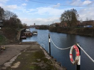
I stopped briefly at Shrewsbury Weir and spotted the fish pass on the opposite bank. It’s good to know that the work we’ve been doing at Worcester to improve fish passage is already available here.
Before setting off I had imagined that the sections through Shrewsbury would be the hardest while trying to walk with a bike. It turned out that this was the easiest section, with the majority of this length being a combined footway and cycle path. Of particular note was the length through the Quarry Parks and Gardens, it looked lovely with hundreds of people enjoying the outdoor space.
There were a few difficult sections with a bike on the far side of Shrewsbury with narrow paths and steep steps that had to be negotiated, before the path returned to open countryside with wide paths across pastureland adjacent to the river.
Then before I knew It I had arrived at Bicton Church. It took me around 3 hours to travel the 22km to this point from Attingham Park.
This is when the bike came into its own. Bicton Church is really close to National Cycle Route 81 which I followed back into Shrewsbury. This took me directly back to Quarry Park next to the river, before heading away from the river on the east side of Shrewsbury. Here the cycle route follows the line of the now abandoned Shrewsbury Canal which reminded me of my previous job as an engineer for CRT. At Upton Magna I joined cycle route 45 which took me back to Attingham Park. I managed to get back to the car in around 1 hour 15 minutes.
It was a thoroughly enjoyable day walking and cycling though I had plenty of cuts and aching muscles to remind me of the trip! Only 3 and bit hours to get back home, stopping off at Holt Fish pass to see how thing were progressing on the way.


Leg 12 – Bridgnorth Golf Club to Buildwas Abbey
Well done to Beth, our Admin Officer, for completing the 12th stretch of the team’s Severn Way walk.
Beth had a few words from her walk –
‘Our walk started pleasantly, with a lengthy section through the Bridgnorth Golf club. We kept up the pace to avoid and stray golf balls, catching glimpses of the river and dramatic cliffs on the other side of the river.
Compared to other stretches of the Severn Way I’ve experienced, the going was relatively easy alongside fields where the path was well-trodden by anglers and dog-walkers alike.
Beyond the golf course, the riverside scenery just kept getting prettier and prettier! Beautiful stretches of trees overhanging the river, weeping willows, alders, and a few tree trunks down. We could also see cyclists going past on the adjacent cycle path. It’s definitely worth a revisit to do this stretch on wheels! We did come across some patches of enormous Japanese Knotweed though, I’ve never seen it so tall and large-leafed.
After an hour or so we came to Coalport, taking a slight diversion from the Way itself due to quite an overgrown stretch. We saw lots of signposts pointed to the museums, including the Jackfield Tile Museum where our Travelling Exhibition had been until recently. All along the riverside path, there were interpretation boards highlighting the industrial heritage, keeping us informed of the historical mining, tile-making, railways and so much more. Within a half-hour or so we reached Ironbridge – the site of the world’s first…iron bridge (1779). A pasty and coffee stop and we were on our way for the final stretch.’


Leg 11 – Severn Valley Country Park to Bridgnorth Golf Club
Well done to Jason, our Programme Director, for completing the 11th stretch of the team’s Severn Way walk.
Jason had a few words from his walk –
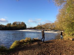
‘A path less walked! Parking at Severn Valley Country park we got the chance to see our amazing play equipment installed 18 months ago. It looks well used and our bow hauler still looks grumpy! The weather was overcast and muggy, and the land was damp after some heavy rain. For the first few miles, the path was well-trodden, the river wide with a series of riffles and pools. Ideal shad spawning habitat. Anglers were making the most of the riverbank with probably over 100 dotted over the first few miles. We spotted a few small islands in the channel, which we weren’t expecting so far down the river. A bit further along we heard the chatter of voices, canoeists paddling downstream, clearly having lots of fun. At this point the path pretty much disappeared, the trail replaced with chest-high wet grass. Needless to say, we were soaked after only short few meters! This was soon replaced by a potato field, the path now between waist-high grass and a potato furrow!
Thankfully the trail returned as a second path joined and we headed to the outskirts of Bridgenorth. Paths of invasive Japanese knotweed were a big feature leading to the town bridge. The town was a welcome site where we had ice cream and a bit of time to dry out!’
You can see photos below!


Leg 10 – Stourport, Treasure Island to Severn Valley Country Park
Well done to Pete, our Waterways Apprentice, for completing the 10th stretch of the team’s Severn Way walk.
Pete had a few words from his walk –
‘This leg of the Severn Way walk started in the town of Stourport. With it being a weekend and fine weather, the riverside walk was very busy with people enjoying picnics, ice-cream and doughnuts. Walking upstream on the eastern bank for the first mile or so there were many caravan and chalet parks. This is clearly a popular destination, and will no doubt be benefitting from many people being forced to take “Stay-cations” this year. As we made our way upstream towards the town of Bewdley I recognised a site where I worked a few days previous with some corporate volunteers from Severn Trent Water. This was Blackstone Riverside Park. The site was on the opposite bank, but the Severn Way took us over and through the Blackstone that the site is named after.
There was a very noticeable change in the river here. The Severn where I do most of my work with volunteers is deep with very little disturbance on the surface. As we get closer to Bewdley, the river shallowed, with a more rocky, gravelly substrate causing riffles. It made me think of the work our project is undertaking, and that the river here would be a preferred area for the twaite shad to come and spawn, once our last fish pass is complete! Once in the town of Bewdley I couldn’t resist checking out the local beer from Bewdley Brewery Ltd.
Upstream of Bewdley we reached Trimpley Reservoir. Here we found a lovely gravel beach on the riverbank where we stopped for a paddle and a break. The walk then took us through woodland to the village of Arley where we crossed the river and continued upstream on the West bank. One thing we noticed was just how many anglers there were out enjoying the river – it was the first Saturday of the fishing season. We saw possibly 10 times more anglers than we did other walkers! I spoke to one of them who said he was fishing for Barbel, but hadn’t caught anything so far. I spotted a kingfisher perched on an overhanging willow branch where we crossed Borle Brook, which enters the Severn near the village of Netherton.
As we neared our finish we arrived at another site popular for volunteering on the project – Severn Valley Country Park. I’d been here a week previously with volunteers tackling invasive weeds. It was good to be back here and was a lovely place to finish this leg of the walk. The wildflowers, and the views across the valley, were beautiful.
You can see photos below!


Leg 9 – Bevere Lock Cottage to Stourport Treasure Island
Well done to Alice, from the Severn Rivers Trust, for completing the 9th stretch of the team’s Severn Way walk.
Alice had a few words from her walk –
‘Almost as soon as we found the Severn Way at Bevere, the footpath swerved away from the river and took us on its own meanders – across farmland, through a caravan park, past a café (handy for a quick coffee stop!), and dodging some grumpy cows until finally, we arrived at the main road bridge at Holt Fleet. We watched the water rushing over weirs and spied the nearly finished fish pass on the opposite bank. From there, the footpath followed the deep, wide, winding and fast-flowing river. The banks were steep, and the way was often overgrown with nettles, brambles, and pesky balsam. We were grateful to the unknown person who has strimmed a narrow path for us to squeeze through. We ate our lunch in a beautiful meadow full of wildflowers. We heard a cuckoo calling! We saw red cliffs, ancient trees, abandoned barges, immaculate static homes, bustling boatyards, and occasional walkers. When we reached Stourport it was all brickwork, canals and lock gates, pub gardens and noisy fairground rides, lots of people enjoying the sun. What a stunning day to explore the river.’
You can see photos below!


Leg 8 – Worcester Riding School, Clifton to Bevere Lock Cottage
Well done to Jennie, our Comms and Marketing Office, for completing the 8th stretch of the team’s Severn Way walk.
Jennie had a few words from her walk –
‘It was a super-hot day when I took my 2 sons to walk Leg 8 of the Severn Way upriver from Clifton. There were some big lakes on the way to the river path. The largest was not marked on our old OS map. We wondered if they were part of a new flood allievement scheme? The backdrop of the Malvern Hills was very dramatic and we enjoyed seeing Oyster Catchers on the lake! For much of this part of the walk unfortunately our view of the river was obscured by great swathes of nettles. And the footpath was very overgrown in places. It did highlight some of the challenges there can be with engaging local people with their river – even if you walk along it, on this section, you can’t necessarily see the river, or its wildlife. It must be a very different story in winter, without nettles and tall grass. Although, the path would be more liable to flooding in the winter! However, we did get to see the May Fly dancing!
When we reached the bypass just outside of Worcester, we had to cut our leg short as the footpath is closed here whilst the roadways team is working on steep embankments under the new bridge. In retrospect, it seems obvious that the path would be closed at this point, but it wasn’t noted on https://www.ldwa.org.uk/ldp/members/show_path.php?path_name=Severn+Way so do be aware there is an issue until the ongoing bypass works at Worcester are completed – especially as there isn’t an effective local diversion (that wouldn’t take you miles away from the river). We will pick up the second part of the walkthrough Worcester, another time!’
You can see Jennie’s photos below!


Leg 7 – Mythe Bridge, Tewkesbury to Worcester Riding School, Clifton
Well done to Pete, Unlocking the Severn Waterways Environment Apprentice, for completing the seventh leg of our Severn Way walk, his second leg of the walk so far!
Pete had some words from his leg –
‘The walk started at the beautiful Mythe Bridge just upstream from Tewkesbury Ham. My immediate impression was how yellow the scenery was. It must be a particularly good year for meadow buttercups as they were covering a wide area both sides of the path, and well into the distance as far as the eye could see. My partner Esther, and my dog Marley, joined me for this walk. The heat was going to cause an issue, as it was a hot day and the sun was on our backs. We had to make regular stops at fishing swims to allow Marley to have a paddle and get a drink in the river. Although shorts and t-shirts were the preferred clothing of choice this did mean getting stung by stinging nettles when wading through overgrown areas. Our first landmark was the M50 bridge which crosses the river near the village of Ripple, about 2.5 miles into the walk. We took this opportunity to have a rest in the shade, and I couldn’t resist the urge to pull up some Himalayan Balsam!
Shortly after the bridge we began to see buildings ahead of us. This was Upton-Upon-Severn, a town which I’ve visited before. I’d heard that Upton Ham was pretty, and a Site of Special Scientific Interest, but I hadn’t known how large it was though! The walk took us along the edge of the Ham on the riverside. The sight of the millions of buttercups in full bloom was impressive. We were also treated to the songs of skylarks and song thrushes, with some oystercatchers flying overhead. It was nice to see an interpretation panel with pictures of some of the fish that inhabit the Severn. I got a different view of Upton from the waters edge. There are many impressive grand buildings indicating that at one time it was a thriving town with wealth, undoubtably provided by trade brought by the river. The sight of people sitting outside the pubs enjoying ice cold drinks was very appealing, but we had plans of our own upstream…
We crossed the river at Upton and headed upstream on the Eastern bank. I’m pleased to say this area had many trees which provided us with some shade. There were several grass meadows on our right-hand side and regularly spotted buzzards and red kites flying overhead. Once we neared the village of Severn Stoke the path took away from the river towards the village. We’d booked a table at the beautiful Red Lion pub in the village where we had a meal and the eagerly anticipated pint of cold beer! After lunch there was just 1.5 miles left of the walk. This part of the walk took us past some large ponds which looked like old gravel pits. Many more birds of prey were hunting in this area including a kestrel. I also think I spotted a footprint of a badger. Our leg of the walk finished at Worcester Riding School, a short distance from the Severn Way walk. We both really enjoyed the beautiful scenery, made particularly special by the views of the Malvern Hills, and all the wildflowers which were thriving on the field edges and Upton Ham.’
You can see Pete’s photos below!


Leg 6 – The White Horse, Gloucester to Mythe Bridge, Tewkesbury
Well done to Hannah, our Events Assistant Apprentice, for completing the 6th stretch of the team’s Severn Way walk.
Hannah had a few words from her walk –
‘We had a slightly rocky start to the walk, with the walking path underwater due to the river being in flood, which meant that we had to start off with a significant diversion in order to meet up with the path further upriver! It wasn’t until The Red Lion pub that we properly joined back up with the river, from here we followed the Severn Way through several very green fields until we met the Haw Bridge. We continued on through lots more beautiful fields full of wild grass and Buttercups and passed by (yet another pub!) The Coalhouse Inn on the outskirts of Apperley. It wasn’t until we reached Deerhurst (near Odda’s Chapel) that the weather gave out on us a bit and we took shelter from the rain until it passed – and then the sun graced us with it presence once more! From there on it was plain sailing (or walking), we made it to Tewkesbury where we skirted the Ham and finally finished the walk at Mythe Bridge, just before the heavens opened once more.’
See Hannah’s photos below!


Leg 5 – Back Lane, Elmore to The White Horse, Gloucester
Well done to Beth, our Admin Officer, for completing the 5th stretch of the team’s Severn Way walk.
Beth had a few words from her walk –
‘The starting point of Elmore is a semi-significant one! My fiancé and I were due to get married in 2020 at the village hall there, so it was strange to go back. Accompanied by my trusty copy of the Severn Way Walk by Terry Marsh, I found the walk itself extremely scenic, with huge stretches going along the river. Weeping willows, alder, and oaks were all coming into leaf. As I got closer to Gloucester, there were a few stretches along a farm track and then back into cattle and sheep fields along the riverside. With a few kilometres to go, I could see Gloucester cathedral start to peak through above the tree line. The recent heavy rain made itself visible as large puddles and pools were forming on the bank. Good job I was in my waterproofs! It’s amazing to see such a tranquil setting just a stone’s throw from the city centre.’
See Beth’s photos below!


Leg 4 – Old Passage Inn, Arlingham to Back Lane, Elmore
Big thanks to Pete, Unlocking the Severn Waterways Environment Apprentice, for completing the fourth leg of our Severn Way walk!
Pete had a few words from his walk –
‘The river at the start was about 300/400m wide. We began by following a series of fields with the river estuary like in appearance. The wildlife here was fantastic as we spotted skylarks, goldfinches, Canadian geese, a stoat or weasel (only saw a quick flash of it), wildflower meadows and two hares. About two miles in there was a sand cliff alongside the river opposite to us. This is where I watched sand martins feeding just above the ground over the path and all around us. Shortly after this we could hear loud engines in the distance. As we got closer we realized they were motocross motorbikes at Milton End Farm. We could hear them from at least 1.5 miles away. The landscape throughout the walk was very flat, a bit like being back in Norfolk! We could see some of the hills of the Cotswolds on our right, with views of the large Gloucester Energy from Waste Facility mostly visible in the distance. Around the area of Pridings the walk came to woodland, where we saw a roe deer stag. The walk then took us onto the road through the village of Framilode. We saw some beautiful wildflowers and orchards near the area of Hill Farm near Farleys End. Unfortunately there were some styles here that Marley couldn’t get through or over, so we were forced back and took a different route which meant walking along a busy road.’
You can see Pete’s photos below!


Leg 3 – Bridge House, Purton to Old Passage Inn, Arlingham
Big thanks to Alex, Unlocking the Severn Senior Project Manager, for completing the third leg of our Severn Way walk!
Alex had a few words from her walk –
‘This walk along the Severn Way is mainly along the Gloucester and Sharpness Canal. The walk is relatively straightforward along generally straight lengths of ship canal, occasionally punctuated by swing bridges. Our walk was busier than expected, but it is a Bank Holiday weekend, and most bridges were operating to allow boats to pass. There were fisherman on the canal edge, lots of people in rowing boats, kayaks etc, as well as the bigger barges and narrowboats, plus hundreds of people walking. We spotted the Slimbridge observation tower early in our walk, and shortly after that had sight of the Severn from a distance, with the familiar shape of May Hill on the hazy horizon. The weather and walking conditions changed (less conducive) as we left the G&S at Fretherne bridge and headed west to join the river. The walk was much quieter along this section to Arlingham, but the views were more dramatic.
You can see Alex’s photos below!


Leg 2 – Olbury Power Station to Bridge House, Purton
Big thanks to Rosie, the Unlocking the Severn Education Officer, for completing the second leg of our Severn Way walk!
Rosie had a few words from her walk –
‘I was blessed with wonderful weather for my walk, and I had the sun all day. The route was relatively quiet, with only a few fellow walkers passing me but I did enjoy the mix of wildlife. Walking a stretch so close to the estuary meant that I saw species of birds that I do not see further upstream, where I live. The route mainly followed the river, with a short detour around Sharpness. I treated myself to an ice-cold orange and lemonade with 2 miles to go, and finished the walk with a trip to the Purton Ship’s Graveyard.’
You can see Rosie’s sunny photos below!


Leg 1 – Severn Bridge to Olbury Power Station
Big thanks to Charles our project shad expert and Senior Technical Fish Specialist at the Environment Agency, for starting the walk off!
Here are some photos of Leg 1 in the beautiful sunshine.